I was in New Orleans a couple of weeks ago and, after an aerial tour from the plane, I got to see some of the residual damage from Hurricane Katrina up close. The photo below was taken during the taxi ride from my hotel to the airport along route 10.
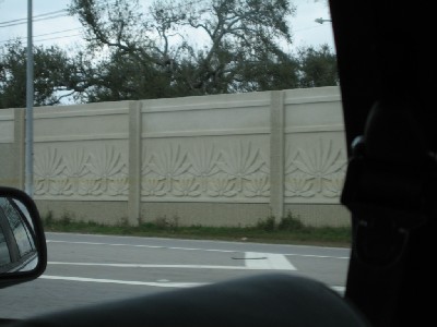
If you look carefully, you’ll notice a dark yellow line about a third of the way up the concrete wall. That’s the mark where the flood waters remained for several days shortly after the storm – a level that my cab driver guessed was about 4 feet above the pavement.
The whole city was relatively quiet, despite the fact it was a few days before the unofficial start of Mardi Gras. I was strolling down Bourbon St. with plenty of room to move around, even though colleagues had warned me that the crowds there would be crazy and packed. I guess it was just an early time of year to be there, as reports this week mentioned that more than 700,000 had come out to celebrate this past weekend.
New Orleans is a very cool city, with perhaps one of the best cuisines I’ve experienced in the U.S. The French influence on Cajun/southern cooking makes for some really tasty combinations. I had never had authentic gumbo before, and now it’s something I crave. The seafood dishes are fantastic as well.
I’m looking forward to going back at some point, maybe when I can time my arrival a little better.
It’s great to see that people are spreading the word of the devestation that still lingers after the hurricane. Pictures don’t do justice to the damage that goes on for miles.
Melisa,
I completely agree that photos don’t do justice to the damage. It was also amazing to see how compartmentalized the damage was — certain areas were completely obliterated and others were still standing as if nothing had happened.